A digital inventory is carried out to prioritize the allocation of funds for the maintenance of existing outdoor lighting lines, heating networks, water utilities, construction and overhaul of lines, heating mains. Identification of unlit streets, driveways and yards, attracting extra-budgetary sources of funding for outdoor lighting, as well as in order to reduce the number of residents' complaints about the state of outdoor lighting.
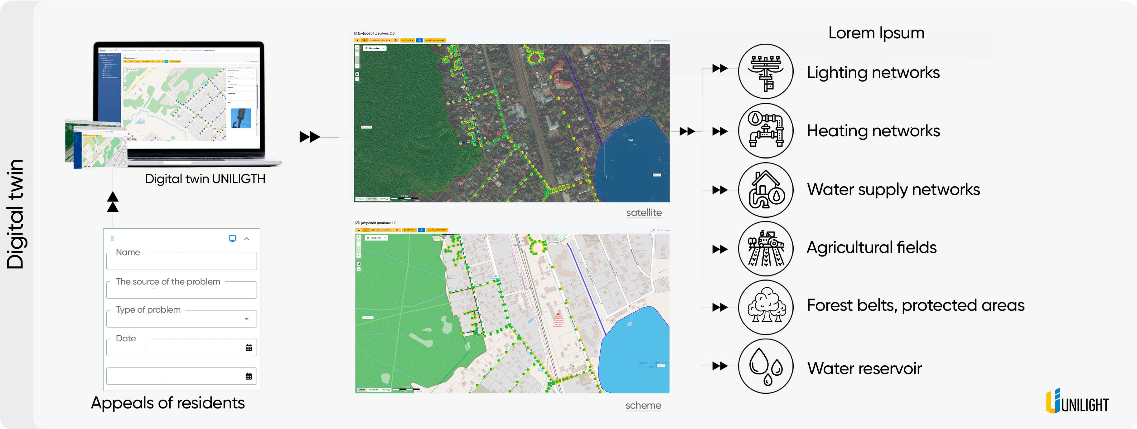
Digital twin layers

Цифровой двойник — это виртуальное или цифровое представление на карте реального или потенциального объекта. Он создается для зданий, сооружений, производств и предприятий сельского хозяйства и любых других необходимых объектов.
Facilities networks digital twin


Lighting networks


  • Detailed information for each pole, control cabinet, luminaire or power line


  • Quick access to instructions and equipment passport


  • Warranty and maintenance tracking

Facilities networks digital twin


Heating network


  • Display on the map of the system of all heat networks


  • Design Mode - Schematic Creation at Design Stage


  • Ability to quickly attach documentation to the object card


  • Quick access to the technical characteristics of the pipeline of each section: diameter, length, material
Facilities networks digital twin


Water supply and sewerage lines


  • Display on the map of the sewerage system and water supply network (external and underground lines)


  • Distribution of the city on the map by operational areas


  • Design Mode - Schematic Creation at Design Stage


  • Display of repair works on the map
Facilities networks digital twin


Forest areas


  • Displaying the system of forest areas on the map


  • Design Mode - Schematic Creation at Design Stage


  • Ability to quickly attach documentation to the object card


  • Quick access to the characteristics of each site
Facilities networks digital twin


Water reservoirs


  • Display on the map of the system of all reservoirs of a given territory


  • Displaying information about the owner or tenant of the site


  • Design Mode - Schematic Creation at Design Stage


  • Displaying the area of ​​a water body, hydraulic connection, objects in a water body
Facilities networks digital twin


Agricultural fields


  • Display on the map of the system of all agricultural fields of a given territory


  • Displaying information about the owner or tenant of the site


  • Ability to quickly attach documentation to the object card


  • Displaying the area of ​​the cultivated field
Facilities networks digital twin

Residents' messaging module


The module allows residents to quickly report on the problems of city life related to housing and communal services, landscaping, urban infrastructure (parking, transport, parks, etc.) and any other.


  • The dispatcher processes the received requests, distributes them among departments, appoints those responsible for the performance of work and deadlines


  • All received requests are grouped into a convenient log


  • A convenient filter, the ability to view requests for a certain period and a color designation of the status of the request


  • Both a one-time download of a report on requests and a subscription to its periodic receipt are available


Request additional information